April 20, 2016
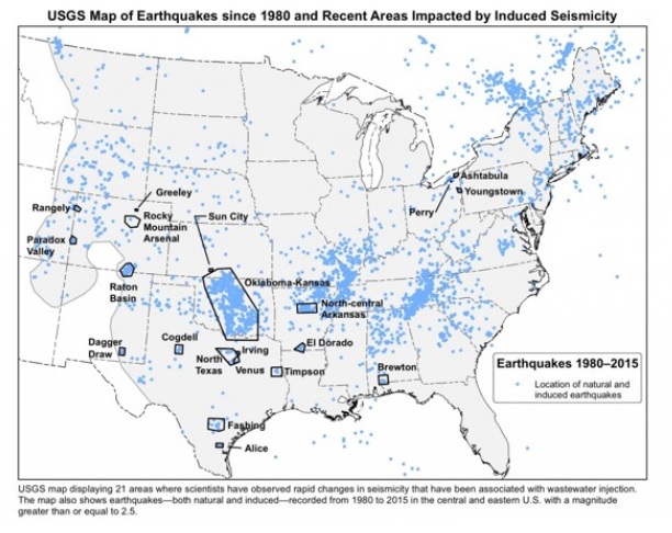
Approximately seven million people live and work in areas of the Central and Eastern U.S. that are at risk of damage from “induced seismicity” - essentially, manmade earthquakes.
That’s according to a new report by the U.S. Geological Service, which, for the first time ever, is including induced seismicity in its national models of earthquake hazards. The agency released maps Monday that identify the potential hazards of such earthquakes alongside those of natural quakes. Causes include wastewater injection, fracking, and other processes that involve pushing fluid underground at high pressure.
“By including human-induced events, our assessment of earthquake hazards has significantly increased in parts of the U.S.,” Mark Petersen, Chief of the USGS National Seismic Hazard Mapping Project, said in a press release.
In some human-induced hotspots, the risk of damaging quakes is roughly on par with that of California. Oklahoma, Kansas, Texas, Colorado, New Mexico, and Arkansas face the biggest hazards. Most earthquakes in these areas hover around a 3.0 magnitude, but a 2011 quake linked to wastewater injection in Oklahoma hit a magnitude of 5.6.
 "My first thought was actually, ‘Holy crap, Oklahoma is redder than California,’" USGS geologist Susan Hough told the Washington Post after she saw the map.
The report also estimates “where, how often, and how strongly earthquake ground shaking could occur in the United States during calendar year 2016,” which is the shortest window for an earthquake forecast the USGS has ever used. “[I]nduced earthquake activity can increase or decrease with time and is subject to commercial and policy decisions that could change rapidly,” the agency writes.
It remains to be seen whether the maps or the report will actually change those decisions, or if they’ll provide information that local engineers or emergency responders don’t already know. But the maps may be something of a watershed in geological mapping. Two centuries after William Smith drew the first modern geological map, visualizing the age, makeup, and relationships of rocks in his native England, the USGS has formally mapped a new force behind Earth’s shifting terrain: People. Behold, a true map for the Anthropocene.
http://www.citylab.com/weather/2016/03/usgs-map-human-induced-earthquake-map/475800/